
Wyandotte County topographic map
Interactive map
Click on the map to display elevation.
About this map
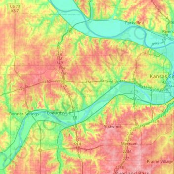
Name: Wyandotte County topographic map, elevation, terrain.
Location: Wyandotte County, Kansas, United States of America (38.99168 -94.90884 39.20307 -94.58820)
Average elevation: 273 m
Minimum elevation: 220 m
Maximum elevation: 336 m
The county's natural topography consists of gently rolling terrain. The Kansas River forms part of the county's southern boundary. The elevation generally increases from south to north as the distance from the Kansas River and Missouri River increases.
Other topographic maps
Click on a map to view its topography, its elevation and its terrain.
Lawrence
United States of America > Kansas > Lawrence
Lawrence, Douglas County, Kansas, United States of America
Average elevation: 265 m