
Thank you for supporting this site ❤️
Make a donation
Make a donation
Selb topographic map
Click on the map to display elevation.
Thank you for supporting this site ❤️
Make a donation
Make a donation
About this map
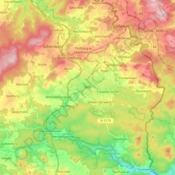
Name: Selb topographic map, elevation, terrain.
Average elevation: 589 m
Minimum elevation: 450 m
Maximum elevation: 739 m
Thank you for supporting this site ❤️
Make a donation
Make a donation
Other topographic maps
Click on a map to view its topography, its elevation and its terrain.
Ziegelhütte
Germany > Bavaria > Landkreis Wunsiedel im Fichtelgebirge > Marktredwitz
Average elevation: 563 m