
Côja topographic map
Interactive map
Click on the map to display elevation.
About this map
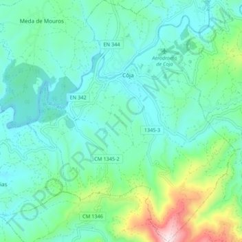
Name: Côja topographic map, elevation, terrain.
Average elevation: 282 m
Minimum elevation: 155 m
Maximum elevation: 760 m
Other topographic maps
Click on a map to view its topography, its elevation and its terrain.
Salgueiral-Coja
Portugal > Centro > Côja e Barril de Alva > Salgueiral-Coja
Salgueiral-Coja, Côja, Côja e Barril de Alva, Arganil, Coimbra, Pinhal Interior Norte, Centro, 3305-143, Portugal
Average elevation: 300 m