
Make a donation
Bylany topographic map
Click on the map to display elevation.
Make a donation
About this map
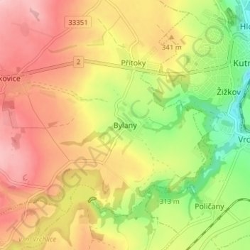
Name: Bylany topographic map, elevation, terrain.
Average elevation: 323 m
Minimum elevation: 231 m
Maximum elevation: 401 m
Make a donation
Other topographic maps
Click on a map to view its topography, its elevation and its terrain.
Make a donation
Make a donation
Make a donation
Make a donation
Make a donation
Make a donation
Make a donation
Make a donation
Stříbrná Skalice
Stříbrná Skalice is located about 26 kilometres (16 mi) southeast of Prague. It lies on the right bank of the Sázava River. The highest point of the municipality is the peak Skalka with an elevation of 516 metres (1,693 ft). There are several ponds, including Hruškov and Propast ponds.
Average elevation: 375 m
Make a donation
okres Praha-západ
The territory of the district forms a half-moon surrounding Prague from the west. The elongated shape of the territory thus extends into different types of landscapes, in the north rather flat, in the south more rugged and hilly. It extends into five geomorphological mesoregions: Prague Plateau (north and…
Average elevation: 343 m
Make a donation
Make a donation
Make a donation
Make a donation
Make a donation
Make a donation
Make a donation
Make a donation