
Thank you for supporting this site ❤️
Make a donation
Make a donation
Annemariental topographic map
Click on the map to display elevation.
Thank you for supporting this site ❤️
Make a donation
Make a donation
About this map
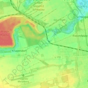
Name: Annemariental topographic map, elevation, terrain.
Average elevation: 104 m
Minimum elevation: 81 m
Maximum elevation: 129 m
Thank you for supporting this site ❤️
Make a donation
Make a donation
Other topographic maps
Click on a map to view its topography, its elevation and its terrain.
Beuna (Geiseltal)
Deutschland > Sachsen-Anhalt > Saalekreis > Merseburg
Annemarienthal | Beuna (Geiseltal) | Elisabethhöhe | Freiimfelde | Geusa | Kötzschen | Merseburg | Meuschau | Neumarkt | Trebnitz | Venenien | Gut Werder
Average elevation: 103 m