
Thank you for supporting this site ❤️
Make a donation
Make a donation
Riverwoods topographic map
Click on the map to display elevation.
Thank you for supporting this site ❤️
Make a donation
Make a donation
About this map
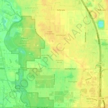
Name: Riverwoods topographic map, elevation, terrain.
Location: Riverwoods, Lake County, Illinois, United States (42.15293 -87.92306 42.19287 -87.87416)
Average elevation: 203 m
Minimum elevation: 186 m
Maximum elevation: 211 m
Thank you for supporting this site ❤️
Make a donation
Make a donation
Other topographic maps
Click on a map to view its topography, its elevation and its terrain.
Thank you for supporting this site ❤️
Make a donation
Make a donation
Thank you for supporting this site ❤️
Make a donation
Make a donation
Bishops Ridge
United States > Illinois > Lake County > Kildeer > Bishops Ridge
Average elevation: 253 m
Thank you for supporting this site ❤️
Make a donation
Make a donation
Lake Naomi
United States > Illinois > Lake County > Hawthorn Woods > White Birch Lakes
Average elevation: 261 m