
Hendersonville topographic map
Interactive map
Click on the map to display elevation.
About this map
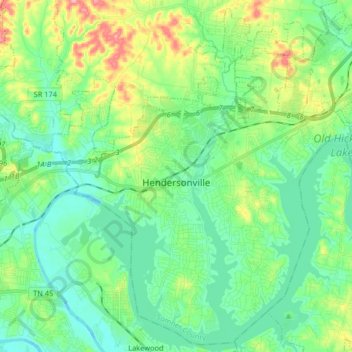
Name: Hendersonville topographic map, elevation, terrain.
Average elevation: 156 m
Minimum elevation: 118 m
Maximum elevation: 257 m
Other topographic maps
Click on a map to view its topography, its elevation and its terrain.
Gallatin
United States > Tennessee > Sumner County
Gallatin, Sumner County, Middle Tennessee, Tennessee, 37066, United States
Average elevation: 166 m
Saundersville
United States > Tennessee > Sumner County > Hendersonville
Saundersville, Hendersonville, Sumner County, Middle Tennessee, Tennessee, 30766, United States
Average elevation: 160 m
Chestnut Hill
United States > Tennessee > Sumner County
Chestnut Hill, Sumner County, Middle Tennessee, Tennessee, United States
Average elevation: 255 m
Cottontown
United States > Tennessee > Sumner County
Cottontown, Sumner County, Middle Tennessee, Tennessee, United States
Average elevation: 200 m
Scottish Highlands
United States > Tennessee > Sumner County > Hendersonville
Scottish Highlands, Hendersonville, Sumner County, Middle Tennessee, Tennessee, 37075, United States
Average elevation: 157 m
Portland
United States > Tennessee > Sumner County
Portland, Sumner County, Middle Tennessee, Tennessee, 37148, United States
Average elevation: 237 m
Cedar Grove
United States > Tennessee > Sumner County > Gallatin
Cedar Grove, Gallatin, Sumner County, Tennessee, 37066, United States
Average elevation: 154 m
Withamtown
United States > Tennessee > Sumner County > Withamtown
Withamtown, Sumner County, Tennessee, 37022, United States
Average elevation: 262 m
Bon Air
United States > Tennessee > Sumner County > Bon Air
Bon Air, Sumner County, Tennessee, United States
Average elevation: 245 m
Castalian Springs
United States > Tennessee > Sumner County > Castalian Springs
Castalian Springs, Sumner County, Tennessee, 37031, United States
Average elevation: 174 m
Bethpage
United States > Tennessee > Sumner County
Bethpage, Sumner County, Middle Tennessee, Tennessee, United States
Average elevation: 193 m
Highland Acres
United States > Tennessee > Sumner County > Hendersonville > Highland Acres
Highland Acres, Hendersonville, Sumner County, Tennessee, 37075, United States
Average elevation: 153 m
Cummings Crossroads
United States > Tennessee > Sumner County > Cummings Crossroads
Cummings Crossroads, Sumner County, Tennessee, 37048, United States
Average elevation: 254 m
White House
United States > Tennessee > Sumner County
White House, Sumner County, Middle Tennessee, Tennessee, 37188, United States
Average elevation: 253 m
Westmoreland
United States > Tennessee > Sumner County
Westmoreland, Sumner County, Middle Tennessee, Tennessee, United States
Average elevation: 271 m