
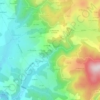
Le Bost topographic map
Interactive map
Click on the map to display elevation.
About this map
Name: Le Bost topographic map, elevation, terrain.
Average elevation: 537 m
Minimum elevation: 382 m
Maximum elevation: 826 m
Other topographic maps
Click on a map to view its topography, its elevation and its terrain.
Champblanc
France > Auvergne-Rhône-Alpes > Puy-de-Dôme > Aubusson-d'Auvergne
Champblanc, Aubusson-d'Auvergne, Thiers, Puy-de-Dôme, Auvergne-Rhône-Alpes, France métropolitaine, 63120, France
Average elevation: 423 m
La Chosserie
France > Auvergne-Rhône-Alpes > Puy-de-Dôme > Aubusson-d'Auvergne
La Chosserie, Aubusson-d'Auvergne, Thiers, Puy-de-Dôme, Auvergne-Rhône-Alpes, France métropolitaine, 63120, France
Average elevation: 491 m