
Thank you for supporting this site ❤️
Make a donation
Make a donation
Santa Maria topographic map
Click on the map to display elevation.
Thank you for supporting this site ❤️
Make a donation
Make a donation
Santa Maria
The topography of Santa Maria is generally flat, however, it is becoming hilly towards the north. This area covers the barangays of Silangan, Mag-asawang Sapa, Pulong Buhangin and some parts of Balasing with landscape ranging from 8 to 18 percent slope. The rest of the barangays have a slope range from level to undulating.
Thank you for supporting this site ❤️
Make a donation
Make a donation
About this map
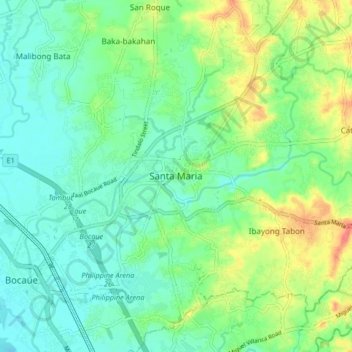
Name: Santa Maria topographic map, elevation, terrain.
Location: Santa Maria, Bulacan, Central Luzon, 3022, Philippines (14.77918 120.92175 14.85918 121.00175)
Average elevation: 18 m
Minimum elevation: 0 m
Maximum elevation: 55 m
Thank you for supporting this site ❤️
Make a donation
Make a donation
Other topographic maps
Click on a map to view its topography, its elevation and its terrain.
Thank you for supporting this site ❤️
Make a donation
Make a donation
Thank you for supporting this site ❤️
Make a donation
Make a donation
Doña Remedios Trinidad
List of highest peaks in D.R.T by elevation.
Average elevation: 172 m
Thank you for supporting this site ❤️
Make a donation
Make a donation