
Make a donation
Jammerdal topographic map
Click on the map to display elevation.
Make a donation
About this map
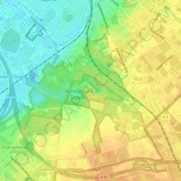
Name: Jammerdal topographic map, elevation, terrain.
Location: Jammerdal, Venlo, Limburg, Nederland (51.34259 6.17052 51.34763 6.18482)
Average elevation: 38 m
Minimum elevation: 19 m
Maximum elevation: 51 m
Make a donation
Other topographic maps
Click on a map to view its topography, its elevation and its terrain.
Blerick
Blerick ligt op de westoever van de Maas, op een hoogte van ongeveer 18 meter. Door een spoorbrug en een verkeersbrug is Blerick met Venlo verbonden. Ten noorden van Blerick vindt men een industriehaven en grootschalige bedrijventerreinen, waartussen de buurtschap Ubroek ligt geklemd. In het westen ligt…
Average elevation: 23 m
Boekend
Boekend ligt op een hoogte van ongeveer 22 meter, in het laagterras van de Maas. Het Koelbroek is een nat natuurgebied dat zich ten noordwesten van Boekend bevindt, langs de Everlose Beek, die in feite een oude Maasmeander volgt. Verder naar het noordwesten ligt een zandige streek, met de voormalige Blerickse…
Average elevation: 24 m
Make a donation