
Golog topographic map
Interactive map
Click on the map to display elevation.
About this map
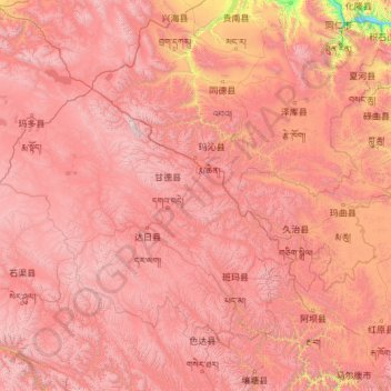
Name: Golog topographic map, elevation, terrain.
Location: Golog, Qinghai, China (32.52460 96.93497 35.62120 101.77730)
Average elevation: 4,177 m
Minimum elevation: 2,568 m
Maximum elevation: 6,039 m
The lay of the land of the prefecture is largely determined by the Amne Machin mountain range (max elevation 6,282 m), which runs in the general northwest- to-southeast direction across the entire prefecture, and beyond. The existence of the ridge results in one of the great bends of the Yellow River, which first flows for several hundreds of kilometers toward the east and southeast along through the entire Golog Prefecture, along the southern side of the Amne Machin Range, until it reaches the borders of Gansu and Sichuan; it and then turns almost 180 degrees and flows toward the northwest for 200–300 km (120–190 mi) through several prefectures of the northeastern Qinghai, forming a section of the northeastern border of the Golog prefecture.
Other topographic maps
Click on a map to view its topography, its elevation and its terrain.
Tanggulashan
Tanggulashan, Golmud, Haixi Mongol and Tibetan Autonomous Prefecture, Qinghai, China
Average elevation: 4,756 m
上赛巴村
China > Qinghai > Chindu County
上赛巴村, Chindu County, Yushu, Qinghai, China
Average elevation: 4,050 m
Golmud City
Golmud City, Haixi Mongol and Tibetan Autonomous Prefecture, Qinghai, 816099, China
Average elevation: 4,324 m
Qumarlêb County
Qumarlêb County, Yushu Tibetan Autonomous Prefecture, Qinghai, China
Average elevation: 4,505 m
Huangnan
China > Qinghai > Tongren City
Huangnan, Tongren City, Huangnan Tibetan Autonomous Prefecture, Qinghai, China
Average elevation: 3,194 m
Golog Tibetan Autonomous Prefecture
China > Qinghai > Gadê County
Golog Tibetan Autonomous Prefecture, Gadê County, Golog Tibetan Autonomous Prefecture, Qinghai, China
Average elevation: 4,340 m
Lamu
China > Qinghai > Hualong Hui Autonomous County
Lamu, Hualong Hui Autonomous County, Haidong, Qinghai, China
Average elevation: 2,256 m
Xireg
China > Qinghai > Ulan County > Xireg
Xireg, Ulan County, Haixi Mongol and Tibetan Autonomous Prefecture, Qinghai, China
Average elevation: 3,248 m
Golog Tibetan Autonomous Prefecture
China > Qinghai > Maqên County > Golog Tibetan Autonomous Prefecture
Golog Tibetan Autonomous Prefecture, Maqên County, Golog Tibetan Autonomous Prefecture, Qinghai, China
Average elevation: 4,148 m
Tanggula Mountains
China > Qinghai > Yanshiping
Tanggula Mountains, Yanshiping, Golmud City, Haixi Mongol and Tibetan Autonomous Prefecture, Qinghai, China
Average elevation: 5,912 m
Yushu Tibetan Autonomous Prefecture
Yushu Tibetan Autonomous Prefecture, Qinghai, China
Average elevation: 4,472 m