
Thank you for supporting this site ❤️
Make a donation
Make a donation
Wiesing topographic map
Click on the map to display elevation.
Thank you for supporting this site ❤️
Make a donation
Make a donation
About this map
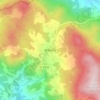
Name: Wiesing topographic map, elevation, terrain.
Location: Wiesing, Viechtach, Landkreis Regen, Bayern, Deutschland (49.09282 12.91309 49.13282 12.95309)
Average elevation: 688 m
Minimum elevation: 484 m
Maximum elevation: 898 m
Thank you for supporting this site ❤️
Make a donation
Make a donation