
Nicolet-Sud topographic map
Interactive map
Click on the map to display elevation.
About this map
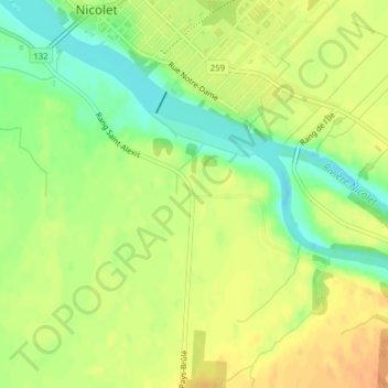
Name: Nicolet-Sud topographic map, elevation, terrain.
Average elevation: 21 m
Minimum elevation: -1 m
Maximum elevation: 37 m
Other topographic maps
Click on a map to view its topography, its elevation and its terrain.
Refuge d'oiseaux migrateurs de Nicolet
Refuge d'oiseaux migrateurs de Nicolet, Route Marie-Victorin, Nicolet, Nicolet-Yamaska, Centre-du-Québec, Québec, J3T, Canada
Average elevation: 11 m