
Traunkirchen topographic map
Interactive map
Click on the map to display elevation.
About this map
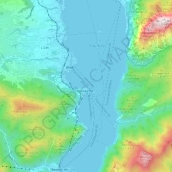
Name: Traunkirchen topographic map, elevation, terrain.
Location: Traunkirchen, Bezirk Gmunden, Oberösterreich, 4801, Österreich (47.82521 13.69733 47.86846 13.80105)
Average elevation: 669 m
Minimum elevation: 417 m
Maximum elevation: 1,649 m
Traunkirchen liegt auf 422 m Höhe am Traunsee.
Other topographic maps
Click on a map to view its topography, its elevation and its terrain.
Traunsee
Österreich > Oberösterreich > Traunkirchen
Traunsee, Aueck, Traunkirchen, Gmunden, Oberösterreich, 4801, Österreich
Average elevation: 729 m