
Thank you for supporting this site ❤️
Make a donation
Make a donation
Malhara topographic map
Click on the map to display elevation.
Thank you for supporting this site ❤️
Make a donation
Make a donation
About this map
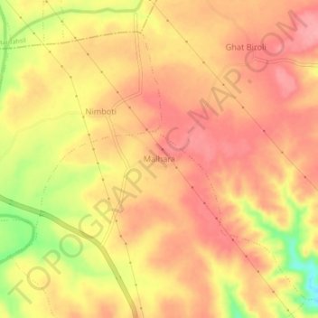
Name: Malhara topographic map, elevation, terrain.
Location: Malhara, Prabhatpattan Tahsil, Betul, Madhya Pradesh, India (21.70459 78.36250 21.74459 78.40250)
Average elevation: 728 m
Minimum elevation: 658 m
Maximum elevation: 760 m
Thank you for supporting this site ❤️
Make a donation
Make a donation
Other topographic maps
Click on a map to view its topography, its elevation and its terrain.