
Wofford Heights topographic map
Interactive map
Click on the map to display elevation.
About this map
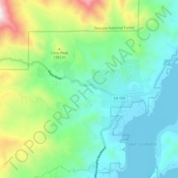
Name: Wofford Heights topographic map, elevation, terrain.
Average elevation: 1,114 m
Minimum elevation: 779 m
Maximum elevation: 2,060 m
Wofford Heights is a census-designated place (CDP) in the southern Sierra Nevada, in Kern County, California, United States. Wofford Heights is located in the west Kern River Valley, 3.5 miles (5.6 km) south-southwest of Kernville, at an elevation of 2,684 feet (818 m). The population was 2,200 at the 2010 census, down from 2,276 at the 2000 census.
Other topographic maps
Click on a map to view its topography, its elevation and its terrain.
Bakersfield
United States > California > Kern County
Bakersfield, Kern County, California, United States
Average elevation: 157 m
Weldon
United States > California > Kern County
Weldon, Kern County, California, 93283, United States
Average elevation: 1,030 m
Bear Valley Springs
United States > California > Kern County
Bear Valley Springs, Kern County, California, United States
Average elevation: 1,204 m
Ridgecrest
United States > California > Kern County
Ridgecrest, Kern County, California, 93555, United States
Average elevation: 739 m
Frazier Park
United States > California > Kern County
Frazier Park, Kern County, California, United States
Average elevation: 1,533 m
Fellows
United States > California > Kern County
Fellows, Kern County, California, United States
Average elevation: 420 m
Potomac County Park
United States > California > Kern County
Potomac County Park, Kern County, California, United States
Average elevation: 130 m
East Bakersfield
United States > California > Kern County
East Bakersfield, Kern County, California, 93305, United States
Average elevation: 158 m
Hillcrest Point
United States > California > Kern County
Hillcrest Point, Kern County, California, United States
Average elevation: 411 m
Rosedale
United States > California > Kern County
Rosedale, Kern County, California, United States
Average elevation: 113 m
Shafter
United States > California > Kern County
Shafter, Kern County, California, 93253, United States
Average elevation: 108 m
South Taft
United States > California > Kern County > Taft > South Taft
South Taft, Taft, Kern County, California, United States
Average elevation: 343 m
Kernville
United States > California > Kern County
Kernville, Kern County, California, 93238, United States
Average elevation: 1,135 m
Ford City
United States > California > Kern County > Taft
Ford City, Taft, Kern County, California, United States
Average elevation: 264 m
Buttonwillow
United States > California > Kern County
Buttonwillow, Kern County, California, 93206, United States
Average elevation: 87 m
Shirley Meadows
United States > California > Kern County
Shirley Meadows, Kern County, California, United States
Average elevation: 1,848 m
Bakersfield
United States > California > Kern County > Bakersfield
Bakersfield, Kern County, California, 93301, United States
Average elevation: 161 m
Blue Moon Ranch
United States > California > Kern County
Blue Moon Ranch, Kern County, California, United States
Average elevation: 77 m
Lost Hills
United States > California > Kern County
Lost Hills, Kern County, California, 93249, United States
Average elevation: 82 m
Lokern
United States > California > Kern County
Lokern, Kern County, California, United States
Average elevation: 89 m
Brown
United States > California > Kern County
Brown, Kern County, California, United States
Average elevation: 732 m
Bodfish
United States > California > Kern County
Bodfish, Kern County, California, 93205, United States
Average elevation: 897 m
Lebec
United States > California > Kern County
Lebec, Kern County, California, 93243, United States
Average elevation: 1,162 m
Quailwood
United States > California > Kern County > Bakersfield
Quailwood, Bakersfield, Kern County, CAL Fire Southern Region, California, 93309, United States
Average elevation: 119 m
Rancho Seco
United States > California > Kern County
Rancho Seco, Kern County, California, United States
Average elevation: 623 m
Stallion Springs
United States > California > Kern County > Stallion Springs
Stallion Springs, Kern County, California, United States
Average elevation: 1,197 m
Brite Lake Recreational Park
United States > California > Kern County
Brite Lake Recreational Park, Kern County, California, United States
Average elevation: 1,354 m
Oildale
United States > California > Kern County
Oildale, Kern County, California, United States
Average elevation: 164 m
Shafter
United States > California > Kern County
Shafter, City of Shafter, Kern County, CAL Fire Southern Region, California, United States
Average elevation: 120 m
California City
United States > California > Kern County
California City, Kern County, California, United States
Average elevation: 845 m
Rosedale
United States > California > Kern County
Rosedale, Kern County, CAL Fire Contract Counties, California, United States
Average elevation: 107 m
Greenfield
United States > California > Kern County
Greenfield, Kern County, California, United States
Average elevation: 106 m
Twin Oaks
United States > California > Kern County
Twin Oaks, Kern County, California, United States
Average elevation: 945 m
Delano
United States > California > Kern County
Delano, Kern County, California, 93215, United States
Average elevation: 99 m
Keene
United States > California > Kern County
Keene, Kern County, California, United States
Average elevation: 892 m
Golden Hills
United States > California > Kern County
Golden Hills, Kern County, California, 93561, United States
Average elevation: 1,275 m
Grapevine
United States > California > Kern County
Grapevine, Kern County, California, United States
Average elevation: 501 m
Sand Canyon
United States > California > Kern County
Sand Canyon, Kern County, California, United States
Average elevation: 936 m
Taft Heights
United States > California > Kern County > Taft > Taft Heights
Taft Heights, Taft, Kern County, California, United States
Average elevation: 368 m
Smith Corner
United States > California > Kern County
Smith Corner, Kern County, CAL Fire Southern Region, California, 93263, United States
Average elevation: 103 m
Inyokern
United States > California > Kern County
Inyokern, Kern County, California, United States
Average elevation: 753 m
City of Bakersfield
United States > California > Kern County
City of Bakersfield, Kern County, California, 93304, United States
Average elevation: 120 m
Taft
United States > California > Kern County
Taft, Kern County, California, 93268, United States
Average elevation: 370 m
Pine Mountain Club
United States > California > Kern County
Pine Mountain Club, Kern County, CAL Fire Southern Region, California, 93222, United States
Average elevation: 1,867 m
Old River
United States > California > Kern County
Old River, Kern County, California, United States
Average elevation: 103 m
Rosamond
United States > California > Kern County
Rosamond, Kern County, California, 93560, United States
Average elevation: 749 m
Woodford
United States > California > Kern County
Woodford, El Rita, Kern County, California, United States
Average elevation: 899 m
Baker
United States > California > Kern County > Boron
Baker, Boron, Kern County, California, United States
Average elevation: 765 m
Arvin
United States > California > Kern County
Arvin, Kern County, California, United States
Average elevation: 130 m
Indian Rocks
United States > California > Kern County
Indian Rocks, Kern County, California, United States
Average elevation: 346 m