
Thank you for supporting this site ❤️
Make a donation
Make a donation
Port Stephens Council topographic map
Click on the map to display elevation.
Thank you for supporting this site ❤️
Make a donation
Make a donation
About this map
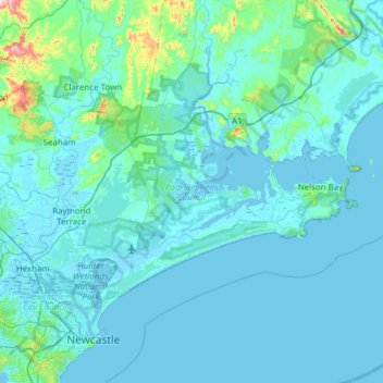
Name: Port Stephens Council topographic map, elevation, terrain.
Location: Port Stephens Council, New South Wales, Australia (-32.87821 151.59350 -32.57885 152.20471)
Average elevation: 25 m
Minimum elevation: -8 m
Maximum elevation: 386 m
Thank you for supporting this site ❤️
Make a donation
Make a donation
Other topographic maps
Click on a map to view its topography, its elevation and its terrain.