
Make a donation
Lombok Tengah topographic map
Click on the map to display elevation.
Make a donation
Lombok Tengah
Central Lombok has a tropical climate with long dry seasons. The rain season normally commences in October and continues until April with an average rainfall of above 100mm during these months. In December falls have reached 382 mm. From May until September average rainfall is below 100 mm with the lowest rainfall normally occurring in May. December normally has the highest frequency of rain days and the lowest occur in May. Topography of Central Lombok is mountainous in the north, including Mount Rinjani area with an altitude of about 1000 meters above sea level, suitable for plantation such as coffee, timber and other crops. The centre of the region is a low-lying and utilised for rice paddies and tobacco. The southern areas are dry and denuded with some undulating hilly areas of between 100 and 355 meters above sea level.
Make a donation
About this map
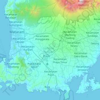
Name: Lombok Tengah topographic map, elevation, terrain.
Average elevation: 289 m
Minimum elevation: -2 m
Maximum elevation: 3,659 m
Make a donation
Other topographic maps
Click on a map to view its topography, its elevation and its terrain.
Make a donation
Rinjani
Indonesia > West Nusa Tenggara
In September 1995 an aviation report was issued concerning an unconfirmed ash cloud from Rinjani. A NOTAM about volcanic activity from Rinjani was issued by the Bali Flight Information Region on the morning of 12 September. An ash cloud was reportedly drifting to the south west with the cloud top around 4 km…
Average elevation: 3,071 m
Make a donation
Tambora
Indonesia > West Nusa Tenggara
Mount Tambora, or Tomboro, is an active stratovolcano in West Nusa Tenggara, Indonesia. Located on Sumbawa in the Lesser Sunda Islands, it was formed by the active subduction zones beneath it. Before the 1815 eruption, its elevation reached more than 4,300 metres (14,100 feet) high, making it one of the…
Average elevation: 1,393 m
Make a donation
Rinjani
Indonesia > West Nusa Tenggara
Mount Rinjani (Indonesian: Gunung Rinjani; Sasak: ᬕᬸᬦ᭄ᬗᬸᬂ᭞ᬭᬶᬦ᭄ᬚᬦᬶ, romanized: gunong rinjani) is an active stratovolcano situated in regencial North Lombok of West Nusa Tenggara province on the Indonesian island of Lombok. It reaches an elevation of 3,726 metres (12,224 ft),…
Average elevation: 3,071 m
Make a donation
Make a donation
Make a donation
Make a donation
Make a donation
Dusun Balekuwu
Indonesia > West Nusa Tenggara > Lombok Barat > Kecamatan Gunungsari
Average elevation: 34 m
Make a donation
Make a donation
Rinjani
Indonesia > West Nusa Tenggara
In September 1995 an aviation report was issued concerning an unconfirmed ash cloud from Rinjani. A NOTAM about volcanic activity from Rinjani was issued by the Bali Flight Information Region on the morning of 12 September. An ash cloud was reportedly drifting to the south west with the cloud top around 4 km…
Average elevation: 3,071 m
Make a donation
Dusun Teloke Laug
Indonesia > West Nusa Tenggara > Lombok Barat > Desa Senteluk
Average elevation: 46 m
Make a donation
Make a donation
Make a donation
Make a donation
Kota Subulussalam
Indonesia > West Nusa Tenggara > Lombok Tengah > Mertak Tombok
Average elevation: 87 m
Make a donation
Tambora
Indonesia > West Nusa Tenggara
Mount Tambora, or Tomboro, is an active stratovolcano in West Nusa Tenggara, Indonesia. Located on Sumbawa in the Lesser Sunda Islands, it was formed by the active subduction zones beneath it. Before 1815, its elevation reached more than 4,300 metres (14,100 feet) high, making it one of the tallest peaks in…
Average elevation: 1,393 m
Make a donation
Dusun Batu Layar
Indonesia > West Nusa Tenggara > Lombok Barat > Desa Batu Layar
Average elevation: 51 m
Make a donation