
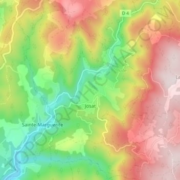
Josat topographic map
Interactive map
Click on the map to display elevation.
About this map
Name: Josat topographic map, elevation, terrain.
Average elevation: 851 m
Minimum elevation: 581 m
Maximum elevation: 1,138 m
Other topographic maps
Click on a map to view its topography, its elevation and its terrain.
Le Viallard
France > Auvergne-Rhône-Alpes > Haute-Loire > Josat
Le Viallard, Josat, Brioude, Haute-Loire, Auvergne-Rhône-Alpes, France métropolitaine, 43230, France
Average elevation: 873 m
Les Fages
France > Auvergne-Rhône-Alpes > Haute-Loire > Josat
Les Fages, Josat, Brioude, Haute-Loire, Auvergne-Rhône-Alpes, France métropolitaine, 43230, France
Average elevation: 947 m