
Jelenia Góra topographic map
Interactive map
Click on the map to display elevation.
About this map
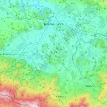
Name: Jelenia Góra topographic map, elevation, terrain.
Location: Jelenia Góra, Lower Silesian Voivodeship, Poland (50.76777 15.57787 50.93256 15.87716)
Average elevation: 518 m
Minimum elevation: 288 m
Maximum elevation: 1,488 m
Other topographic maps
Click on a map to view its topography, its elevation and its terrain.
Sobieszów
Poland > Lower Silesian Voivodeship > Jelenia Góra
Sobieszów, Jelenia Góra, Lower Silesian Voivodeship, 58-570, Poland
Average elevation: 411 m
Karkonosze
Poland > Lower Silesian Voivodeship > Jelenia Góra
Karkonosze, Jelenia Góra, Lower Silesian Voivodeship, Poland
Average elevation: 1,196 m
Jelenia Góra
Poland > Lower Silesian Voivodeship > Jelenia Góra
Jelenia Góra, Karkonosze County, Lower Silesian Voivodeship, Poland
Average elevation: 580 m