
Dunure topographic map
Interactive map
Click on the map to display elevation.
About this map
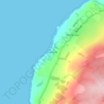
Name: Dunure topographic map, elevation, terrain.
Average elevation: 69 m
Minimum elevation: -1 m
Maximum elevation: 274 m
Other topographic maps
Click on a map to view its topography, its elevation and its terrain.
Dailly
Vereinigtes Königreich > Schottland > South Ayrshire
Dailly, South Ayrshire, Schottland, KA26 9SD, Vereinigtes Königreich
Average elevation: 94 m
Straiton
Vereinigtes Königreich > Schottland > South Ayrshire
Straiton, South Ayrshire, Schottland, KA19 7NF, Vereinigtes Königreich
Average elevation: 186 m
Heads of Ayr Farm Park
Vereinigtes Königreich > Schottland > South Ayrshire
Heads of Ayr Farm Park, South Ayrshire, Schottland, Vereinigtes Königreich
Average elevation: 60 m
Troon
Vereinigtes Königreich > Schottland > South Ayrshire
Troon, South Ayrshire, Schottland, KA10 6AZ, Vereinigtes Königreich
Average elevation: 11 m