
Wurtzbourg topographic map
Interactive map
Click on the map to display elevation.
About this map
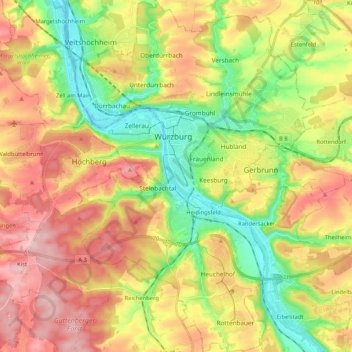
Name: Wurtzbourg topographic map, elevation, terrain.
Location: Wurtzbourg, Bavière, Allemagne (49.71068 9.87163 49.84546 10.01443)
Average elevation: 270 m
Minimum elevation: 166 m
Maximum elevation: 385 m
Other topographic maps
Click on a map to view its topography, its elevation and its terrain.
Landkreis Traunstein
Landkreis Traunstein, Bavière, Allemagne
Average elevation: 644 m
Weil
Allemagne > Bavière > Landkreis Landsberg am Lech > Weil
Weil, Landkreis Landsberg am Lech, Bavière, 86947, Allemagne
Average elevation: 582 m
Ettenhausen
Allemagne > Bavière > Landkreis Traunstein
Ettenhausen, Schleching, Landkreis Traunstein, Bavière, 83259, Allemagne
Average elevation: 794 m
Schleching
Allemagne > Bavière > Schleching
Schleching, Landkreis Traunstein, Bavière, 83259, Allemagne
Average elevation: 958 m
Landkreis Aichach-Friedberg
Landkreis Aichach-Friedberg, Souabe, Bavière, Allemagne
Average elevation: 489 m
Herpersdorf
Allemagne > Bavière > Nuremberg > Herpersdorf
Herpersdorf, Nuremberg, Moyenne-Franconie, Bavière, 90455, Allemagne
Average elevation: 333 m
Marktschellenberg
Allemagne > Bavière > Landkreis Berchtesgadener Land
Marktschellenberg, Landkreis Berchtesgadener Land, Bavière, 83487, Allemagne
Average elevation: 708 m
Würzburg Altstadt
Allemagne > Bavière > Wurtzbourg
Würzburg Altstadt, Wurtzbourg, Würzburg, Basse-Franconie, Bavière, 97070, Allemagne
Average elevation: 204 m
Grafenwöhr
Allemagne > Bavière > Grafenwöhr
Grafenwöhr, Landkreis Neustadt an der Waldnaab, Haut-Palatinat, Bavière, 92655, Allemagne
Average elevation: 450 m
Berchtesgaden
Allemagne > Bavière > Landkreis Berchtesgadener Land
Berchtesgaden, Landkreis Berchtesgadener Land, Bavière, 83471, Allemagne
Average elevation: 817 m