
Parque Patricios topographic map
Interactive map
Click on the map to display elevation.
About this map
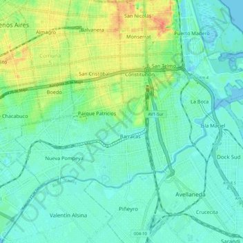
Name: Parque Patricios topographic map, elevation, terrain.
Location: Comuna 4, Parque Patricios, CABA, Argentina (-34.66261 -58.43494 -34.61798 -58.33512)
Average elevation: 14 m
Minimum elevation: -3 m
Maximum elevation: 48 m
Other topographic maps
Click on a map to view its topography, its elevation and its terrain.