
Thank you for supporting this site ❤️
Make a donation
Make a donation
Kaohsiung topographic map
Click on the map to display elevation.
Thank you for supporting this site ❤️
Make a donation
Make a donation
About this map
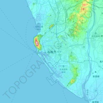
Name: Kaohsiung topographic map, elevation, terrain.
Location: Kaohsiung, Taiwan (22.46033 120.15204 22.78033 120.47204)
Average elevation: 14 m
Minimum elevation: -4 m
Maximum elevation: 339 m
Thank you for supporting this site ❤️
Make a donation
Make a donation
Other topographic maps
Click on a map to view its topography, its elevation and its terrain.
Thank you for supporting this site ❤️
Make a donation
Make a donation
Sanxia District
Taiwan > New Taipei > Special-use Zone of National Taipei University
Average elevation: 349 m