
Passaic County topographic map
Interactive map
Click on the map to display elevation.
About this map
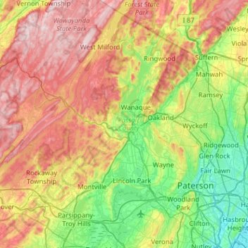
Name: Passaic County topographic map, elevation, terrain.
Location: Passaic County, New Jersey, USA (40.81993 -74.50288 41.20289 -74.10679)
Average elevation: 182 m
Minimum elevation: 0 m
Maximum elevation: 451 m
Other topographic maps
Click on a map to view its topography, its elevation and its terrain.
Burlington City
USA > New Jersey > Burlington City
Burlington City, Burlington County, New Jersey, 08016, USA
Average elevation: 6 m
National Park
USA > New Jersey > National Park
National Park, Gloucester County, New Jersey, 08063, USA
Average elevation: 4 m