
Make a donation
Nordland topographic map
Click on the map to display elevation.
Make a donation
Nordland
In the geological past, a collision with Greenland pushed long slices of the seabed on top of the existing bedrock, today forming the bedrock from Dovrefjell and Trollheimen south of Trondheim stretching north in Trøndelag and through Nordland to justh north of Tromsø. This Cambrian—Silurian bedrock, much of it mica schist, is by far the largest area in Norway with soft bedrock rich in nutritions good for plant growth. It forms the bedrock in the fjord areas, while the islands off the coast and some of the easternmost areas along the border with Sweden are made up of hard bedrock (usually granite). In some areas, as in Tysfjord and Sørfold, the bedrock is a mix of soft bedrock and hard granite. Much of the Lofoten mountains are of precambrian eruptive origin and 3.5 billion years old, among the oldest on earth. The youngest rock in Norway is on Andøya, also known for its fossils of dinosaurs and other life forms. As the land was depressed by the ice sheet in the ice age, substantial areas in the lowest altitudes was beneath the surface of the sea for thousands of years acquiring marine deposits. Due to post-glacial rebound, this is now dry land, reaching 120 metres (390 ft) above sea level today in Saltdal, 100 metres (330 ft) in Narvik and Brønnøysund, and 30 metres (98 ft) to 50 metres (160 ft) in Lofoten and Vesterålen. Limestone is very common in Nordland, with many caves throughout the county, such as Grønligrotta in Rana. There are more caves in Rana than any other area in northern Europe. In August 2006 the Tjoarvekrajgge cave in Sørfold was explored and verified as the longest cave in Scandinavia 22 kilometres (14 mi) long); Raggejavreraige in Tysfjord is the deepest in Scandinavia and Svarthamarhola in Fauske has the largest cavity. There are more than 900 caves in Nordland, one of these have a 70 metres (230 ft) high waterfall. Marble is found in several locations. Fauske is sometimes referred to as the marble capital, and has exported marble worldwide (one customer being the UN building in New York City).
Make a donation
About this map
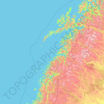
Name: Nordland topographic map, elevation, terrain.
Location: Nordland, Norway (64.93950 10.57806 69.59670 18.15135)
Average elevation: 259 m
Minimum elevation: -3 m
Maximum elevation: 1,940 m
Make a donation
Other topographic maps
Click on a map to view its topography, its elevation and its terrain.
Pulpit Rock
The walk to Preikestolen is very steep in places. The path starts at the Preikestolhytta, at an elevation of approximately 270 metres (890 ft) above sea level, and climbs to 604 metres (1,982 ft). The walk takes 2–3 hours depending on traffic along the trail, experience, and fitness level. Even though the…
Average elevation: 289 m
Make a donation
Make a donation
Make a donation
Make a donation
Bodø - Bådåddjo
Snow cover during winter varies, and is often sparse or lacking in the city center, while being more reliable only slightly inland or at some altitude. The largest recorded snow depth at the airport is 90 centimetres (35 in) in February 1976. Located on a peninsula in the Norwegian Sea, Bodø is known to be a…
Average elevation: 74 m
Make a donation
Trondheim
Trondheim is situated where the River Nidelva meets Trondheim Fjord with an excellent harbour and sheltered condition. The river used to be deep enough for most boats in the Middle Ages. An avalanche of mud and stones made it less navigable and partly ruined the harbour in the mid-17th century. The…
Average elevation: 118 m
Make a donation
Make a donation
Make a donation
Make a donation
Make a donation
Make a donation
Make a donation
Make a donation
Make a donation
Make a donation
Make a donation
Make a donation
Make a donation
Make a donation
Make a donation
Make a donation
Make a donation
Make a donation
Make a donation
Make a donation