
Pichilemu topographic map
Interactive map
Click on the map to display elevation.
About this map
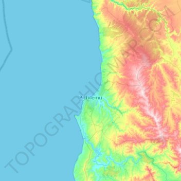
Name: Pichilemu topographic map, elevation, terrain.
Average elevation: 127 m
Minimum elevation: 0 m
Maximum elevation: 602 m
Pichilemu is located 126 kilometres (78 mi) west of San Fernando, in the westernmost area of the O'Higgins Region, on the coast of the Pacific Ocean. It is within a three-hour drive of the Andes Mountains. It is near the Cordillera de la Costa (Coastal Mountain Range) which rises to 2,000 metres (6,562 ft) in elevation.