
Huamantla topographic map
Interactive map
Click on the map to display elevation.
About this map
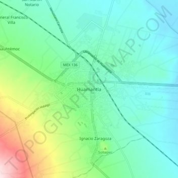
Name: Huamantla topographic map, elevation, terrain.
Location: Huamantla, Tlaxcala, 90501, Mexico (19.27343 -97.96302 19.35343 -97.88302)
Average elevation: 2,519 m
Minimum elevation: 2,419 m
Maximum elevation: 2,835 m
The municipality is located in the eastern half of the state of Tlaxcala, in the Central Mexican Highlands. It has an average altitude of 2,500 meters above sea level. The geography of the municipality has three types of relief. About twenty percent is rugged mountain (located in the far north and far south), about thirty percent is semi-flat (located I the north and south and over half which is flat, in the center. Its far south is part of the Malinche Volcano.