
Thank you for supporting this site ❤️
Make a donation
Make a donation
Talladega Mountain topographic map
Click on the map to display elevation.
Thank you for supporting this site ❤️
Make a donation
Make a donation
About this map
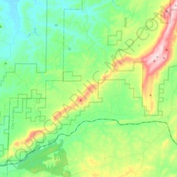
Name: Talladega Mountain topographic map, elevation, terrain.
Location: Talladega Mountain, Clay County, Alabama, United States (33.32904 -85.98941 33.45095 -85.81539)
Average elevation: 338 m
Minimum elevation: 177 m
Maximum elevation: 703 m
Thank you for supporting this site ❤️
Make a donation
Make a donation
Other topographic maps
Click on a map to view its topography, its elevation and its terrain.
Thank you for supporting this site ❤️
Make a donation
Make a donation
Thank you for supporting this site ❤️
Make a donation
Make a donation