
Thank you for supporting this site ❤️
Make a donation
Make a donation
Chiconi topographic map
Click on the map to display elevation.
Thank you for supporting this site ❤️
Make a donation
Make a donation
About this map
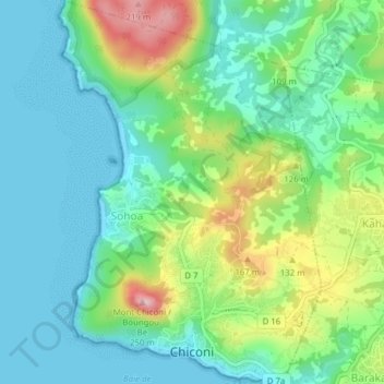
Name: Chiconi topographic map, elevation, terrain.
Location: Chiconi, Mayotte, 97670, France (-12.83977 45.09925 -12.80192 45.12586)
Average elevation: 65 m
Minimum elevation: 0 m
Maximum elevation: 226 m
Thank you for supporting this site ❤️
Make a donation
Make a donation
Other topographic maps
Click on a map to view its topography, its elevation and its terrain.