
Thank you for supporting this site ❤️
Make a donation
Make a donation
Fago topographic map
Click on the map to display elevation.
Thank you for supporting this site ❤️
Make a donation
Make a donation
About this map
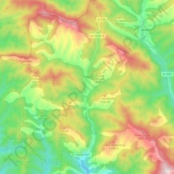
Name: Fago topographic map, elevation, terrain.
Location: Fago, La Jacetania, Huesca, Aragón, 22729, España (42.68999 -0.92246 42.76898 -0.84941)
Average elevation: 1,007 m
Minimum elevation: 672 m
Maximum elevation: 1,455 m
Thank you for supporting this site ❤️
Make a donation
Make a donation
Other topographic maps
Click on a map to view its topography, its elevation and its terrain.
San Juan de la Peña
España > Aragón > La Jacetania > Santa Cruz de la Serós
Average elevation: 1,199 m