
Thank you for supporting this site ❤️
Make a donation
Make a donation
Vessigny topographic map
Click on the map to display elevation.
Thank you for supporting this site ❤️
Make a donation
Make a donation
About this map
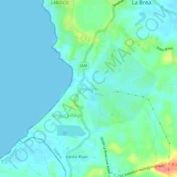
Name: Vessigny topographic map, elevation, terrain.
Location: Vessigny, Siparia, Trinidad and Tobago (10.19756 -61.64800 10.23756 -61.60800)
Average elevation: 15 m
Minimum elevation: -3 m
Maximum elevation: 83 m
Thank you for supporting this site ❤️
Make a donation
Make a donation
Other topographic maps
Click on a map to view its topography, its elevation and its terrain.