
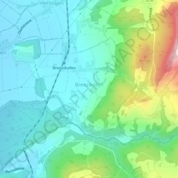
Brenzikofen topographic map
Interactive map
Click on the map to display elevation.
About this map
Name: Brenzikofen topographic map, elevation, terrain.
Average elevation: 664 m
Minimum elevation: 560 m
Maximum elevation: 981 m
Other topographic maps
Click on a map to view its topography, its elevation and its terrain.
Wald (BE)
Zwitserland > Bern/Berne > Verwaltungskreis Bern-Mittelland
Wald (BE), Verwaltungskreis Bern-Mittelland, Verwaltungsregion Bern-Mittelland, Bern/Berne, 3086, Zwitserland
Average elevation: 785 m
Herrenschwanden
Zwitserland > Bern/Berne > Verwaltungskreis Bern-Mittelland
Herrenschwanden, Kirchlindach, Verwaltungskreis Bern-Mittelland, Verwaltungsregion Bern-Mittelland, Bern/Berne, 3037, Zwitserland
Average elevation: 560 m
Mühledorf
Zwitserland > Bern/Berne > Verwaltungskreis Bern-Mittelland > Mühledorf
Mühledorf, Kirchdorf (BE), Verwaltungskreis Bern-Mittelland, Verwaltungsregion Bern-Mittelland, Bern/Berne, 3116, Zwitserland
Average elevation: 591 m
Münsingen
Zwitserland > Bern/Berne > Verwaltungskreis Bern-Mittelland > Münsingen
Münsingen, Verwaltungskreis Bern-Mittelland, Verwaltungsregion Bern-Mittelland, Bern/Berne, Zwitserland
Average elevation: 625 m
Bern
Zwitserland > Bern/Berne > Verwaltungskreis Bern-Mittelland
Bern, Verwaltungskreis Bern-Mittelland, Verwaltungsregion Bern-Mittelland, Bern/Berne, Zwitserland
Average elevation: 612 m