
Thank you for supporting this site ❤️
Make a donation
Make a donation
Saratoga topographic map
Click on the map to display elevation.
Thank you for supporting this site ❤️
Make a donation
Make a donation
About this map
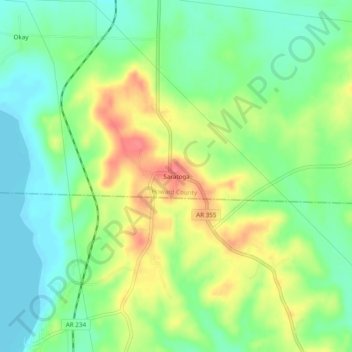
Name: Saratoga topographic map, elevation, terrain.
Location: Saratoga, Howard County, Arkansas, 71859, United States (33.73175 -93.92280 33.77175 -93.88280)
Average elevation: 106 m
Minimum elevation: 78 m
Maximum elevation: 146 m
Thank you for supporting this site ❤️
Make a donation
Make a donation
Other topographic maps
Click on a map to view its topography, its elevation and its terrain.