
Thank you for supporting this site ❤️
Make a donation
Make a donation
Maysville topographic map
Click on the map to display elevation.
Thank you for supporting this site ❤️
Make a donation
Make a donation
About this map
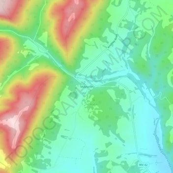
Name: Maysville topographic map, elevation, terrain.
Location: Maysville, Grant County, West Virginia, 26833, United States (39.09511 -79.18476 39.13511 -79.14476)
Average elevation: 474 m
Minimum elevation: 347 m
Maximum elevation: 722 m
Thank you for supporting this site ❤️
Make a donation
Make a donation
Other topographic maps
Click on a map to view its topography, its elevation and its terrain.