
Düren topographic map
Interactive map
Click on the map to display elevation.
About this map
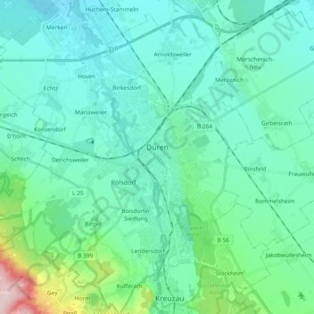
Name: Düren topographic map, elevation, terrain.
Location: Düren, Kreis Düren, Rhénanie-du-Nord-Westphalie, Allemagne (50.74098 6.38563 50.85760 6.53841)
Average elevation: 145 m
Minimum elevation: 102 m
Maximum elevation: 374 m
Other topographic maps
Click on a map to view its topography, its elevation and its terrain.
Hürtgen
Allemagne > Rhénanie-du-Nord-Westphalie > Kreis Düren > Hürtgenwald > Hürtgen
Hürtgen, Hürtgenwald, Kreis Düren, Rhénanie-du-Nord-Westphalie, 52393, Allemagne
Average elevation: 371 m
Nideggen
Allemagne > Rhénanie-du-Nord-Westphalie > Kreis Düren
Nideggen, Kreis Düren, Rhénanie-du-Nord-Westphalie, 52385, Allemagne
Average elevation: 300 m