
Gifford Pinchot National Forest topographic map
Interactive map
Click on the map to display elevation.
About this map
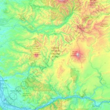
Name: Gifford Pinchot National Forest topographic map, elevation, terrain.
Average elevation: 769 m
Minimum elevation: -1 m
Maximum elevation: 3,703 m
Gifford Pinchot National Forest is located in a mountainous region approximately between Mount St. Helens to the west, Mount Adams to the east, Mount Rainier National Park to the north, and the Columbia River to the south. This region of Southwest Washington is noted for its complex topography and volcanic geology. About 65 percent of the forest acreage is located in Skamania County. In descending order of land area the others are Lewis, Yakima, Cowlitz, and Klickitat counties.
Other topographic maps
Click on a map to view its topography, its elevation and its terrain.
Spirit Lake
United States > Washington > Skamania County
Spirit Lake, Skamania County, Washington, United States
Average elevation: 1,144 m
Mount Saint Helens
United States > Washington > Skamania County
Mount Saint Helens, Skamania County, Washington, United States
Average elevation: 2,096 m