
Make a donation
Santa Elena topographic map
Click on the map to display elevation.
Make a donation
About this map
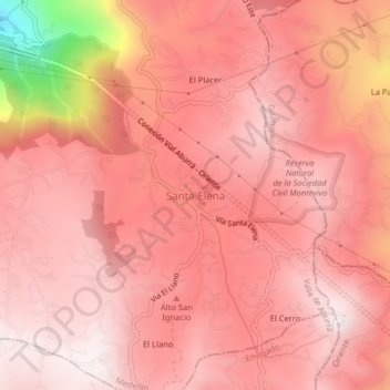
Name: Santa Elena topographic map, elevation, terrain.
Average elevation: 2,547 m
Minimum elevation: 1,879 m
Maximum elevation: 2,732 m
Make a donation
Other topographic maps
Click on a map to view its topography, its elevation and its terrain.
Comuna 14 - El Poblado
Colombia > Antioquia > Medellín
El Poblado consists of 1,432.58 hectares (3,540.0 acres), encompassing 39% of the Medellín municipality. It is located in the southeastern zone of the city towards the mountains of the Aburrá Valley. The Medellín River borders its western side, separating it from the Guayabal Commune and its elevation east…
Average elevation: 1,732 m
Make a donation