
Yaracuy topographic map
Interactive map
Click on the map to display elevation.
About this map
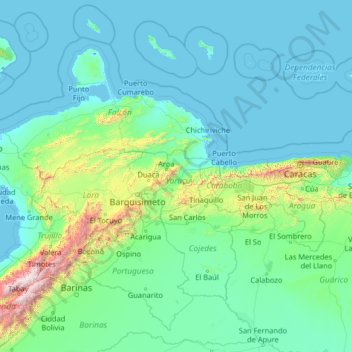
Name: Yaracuy topographic map, elevation, terrain.
Location: Yaracuy, Región Centroccidental, Venezuela (7.77333 -71.31000 12.89333 -66.19000)
Average elevation: 253 m
Minimum elevation: -5 m
Maximum elevation: 4,773 m
Other topographic maps
Click on a map to view its topography, its elevation and its terrain.
Campo Elías
Venezuela > Yaracuy > Municipio Bruzual
Campo Elías, Parroquia Campo Elías, Municipio Bruzual, Yaracuy, 3209, Venezuela
Average elevation: 655 m