
Thank you for supporting this site ❤️
Make a donation
Make a donation
Esslingen topographic map
Click on the map to display elevation.
Thank you for supporting this site ❤️
Make a donation
Make a donation
About this map
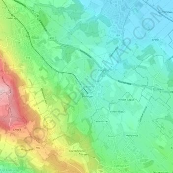
Name: Esslingen topographic map, elevation, terrain.
Location: Esslingen, Egg, Bezirk Uster, Zürich, 8133, Schweiz (47.26919 8.68963 47.30919 8.72963)
Average elevation: 536 m
Minimum elevation: 440 m
Maximum elevation: 756 m
Thank you for supporting this site ❤️
Make a donation
Make a donation
Other topographic maps
Click on a map to view its topography, its elevation and its terrain.
Volketswil
Schweiz > Zürich > Bezirk Uster
Das Dorf Volketswil fügt sich ein zwischen die zwei Moränenhügel Hutzlen und Homberg, die durch den Linthgletscher entstanden sind. In Richtung Hegnau-Dammboden Zimikon ist die Landschaft leicht abfallend. Hegnau ist ein typisches Strassendorf: Das Strassen-Trassee der Nationalstrasse…
Average elevation: 495 m
Thank you for supporting this site ❤️
Make a donation
Make a donation