
Aalen topographic map
Interactive map
Click on the map to display elevation.
About this map
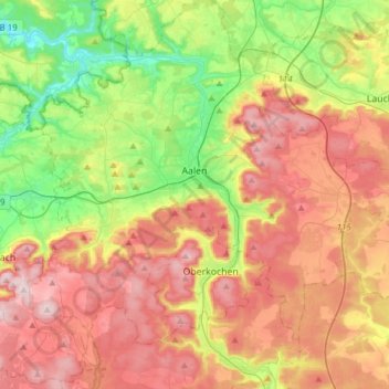
Name: Aalen topographic map, elevation, terrain.
Average elevation: 554 m
Minimum elevation: 359 m
Maximum elevation: 771 m
Other topographic maps
Click on a map to view its topography, its elevation and its terrain.
Rechberg
Duitsland > Baden-Württemberg > Ostalbkreis > Schwäbisch Gmünd
Rechberg, Schwäbisch Gmünd, Verwaltungsgemeinschaft Schwäbisch Gmünd, Ostalbkreis, Baden-Württemberg, 73529, Duitsland
Average elevation: 491 m
Eschach
Duitsland > Baden-Württemberg > Ostalbkreis > Eschach
Eschach, Verwaltungsverband Leintal-Frickenhofer Höhe, Ostalbkreis, Baden-Württemberg, 73569, Duitsland
Average elevation: 476 m