
Limekiln topographic map
Interactive map
Click on the map to display elevation.
About this map
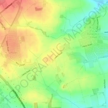
Name: Limekiln topographic map, elevation, terrain.
Average elevation: 89 m
Minimum elevation: 55 m
Maximum elevation: 122 m
Other topographic maps
Click on a map to view its topography, its elevation and its terrain.
Churwell
United Kingdom > England > Leeds
Churwell, Leeds, West Yorkshire, England, LS27 7QR, United Kingdom
Average elevation: 96 m
Ledston
United Kingdom > England > Leeds
Ledston, Leeds, West Yorkshire, England, United Kingdom
Average elevation: 45 m
East Rigton
United Kingdom > England > Leeds
East Rigton, Leeds, West Yorkshire, England, LS17 9AZ, United Kingdom
Average elevation: 72 m
Bramhope
United Kingdom > England > Leeds > Bramhope
Bramhope, Leeds, West Yorkshire, England, United Kingdom
Average elevation: 143 m
Boston Spa
United Kingdom > England > Leeds > Wetherby
Boston Spa, Wetherby, Leeds, West Yorkshire, England, United Kingdom
Average elevation: 34 m
Kippax
United Kingdom > England > Leeds > Great Preston
Kippax, Great Preston, Leeds, West Yorkshire, England, United Kingdom
Average elevation: 56 m
Yeadon
United Kingdom > England > Leeds
Yeadon, Leeds, West Yorkshire, England, LS19 7RS, United Kingdom
Average elevation: 142 m
Guiseley
United Kingdom > England > Leeds
Guiseley, Leeds, West Yorkshire, England, LS20 9FN, United Kingdom
Average elevation: 140 m