
Make a donation
Kolkata topographic map
Click on the map to display elevation.
Make a donation
About this map
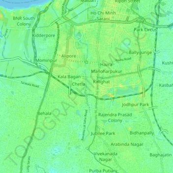
Name: Kolkata topographic map, elevation, terrain.
Location: Kolkata, Kolkata District, West Bengal, India, Adi Ganga (22.47587 88.32452 22.55060 88.35527)
Average elevation: 8 m
Minimum elevation: -1 m
Maximum elevation: 18 m
Make a donation
Other topographic maps
Click on a map to view its topography, its elevation and its terrain.
Darjeeling
The Darjeeling hill area is formed of comparatively recent rock structure that has a direct bearing on landslides. Heavy monsoon precipitation contributes to the landslides. Soils of Darjeeling hill areas are extremely varied, depending on elevation, degree of slope, vegetative cover and geolithology.
Average elevation: 730 m
Kolkata
Spread roughly north–south along the east bank of the Hooghly River, Kolkata sits within the lower Ganges Delta of eastern India approximately 75 km (47 mi) west of the international border with Bangladesh; the city's elevation is 1.5–9 m (5–30 ft). Much of the city was originally a wetland that was…
Average elevation: 5 m
Chakdaha
India > West Bengal > Chakdaha
Chakdaha is a prominent urban local body in the district of Nadia, one of the southern districts of West Bengal. Chakdaha's location is 23°05′N 88°31′E / 23.08°N 88.52°E / 23.08; 88.52. It has an average elevation of 11 meters (36 feet) and is 62 km north of the state capital, Kolkata. It is…
Average elevation: 10 m
Kolkata
Spread roughly north–south along the east bank of the Hooghly River, Kolkata sits within the lower Ganges Delta of eastern India approximately 75 km (47 mi) west of the international border with Bangladesh; the city's elevation is 1.5–9 m (5–30 ft). Much of the city was originally a wetland that was…
Average elevation: 5 m
Make a donation
Purulia
Several rivers flow across Purulia district. Among these Kangsabati, Kumari, Silabati(silai), Dwarakeswar, Subarnarekha and Damodar are the important ones. Although several rivers flows across the district, 50% of the water run off due to the undulated topography. There are also several Small dams like…
Average elevation: 225 m
Birbhum
Often called "the land of red soil", Birbhum is noted for its topography and its cultural heritage which is somewhat different from the other districts in West Bengal. The western part of Birbhum is a bushy region, a part of the Chhota Nagpur Plateau. This region gradually merges with the fertile alluvial…
Average elevation: 70 m
Make a donation
Mathurapur - I
Mathurapur I CD block is located at 22°07′13″N 88°23′39″E / 22.1203°N 88.3943°E / 22.1203; 88.3943. It has an average elevation of 7 metres (23 ft).
Average elevation: 4 m
Make a donation
Uttar Dinajpur
The regional topography is generally flat with a gentle southerly slope towards which the main rivers like Kulik, Nagar, Mahananda. The District forms a part of the basin lying between Rajmahal hills on the east. The older alluvium is estimated to be Pleistocene age. Uttar Dinajpur is bestowed with a very…
Average elevation: 45 m
Baruipur
The Baruipur CD block is located at 22°21′56″N 88°25′57″E / 22.3654432°N 88.4325028°E / 22.3654432; 88.4325028. It has an average elevation of 9 metres (30 ft).
Average elevation: 4 m
Purba Medinipur
Purba Medinipur district is part of the lower Indo-Gangetic Plain and Eastern coastal plains. Topographically, the district can be divided into two parts – (a) almost entirely flat plains on the west, east and north, (b) the coastal plains on the south. The vast expanse of land is formed of alluvium and is…
Average elevation: 6 m
Make a donation
Canning - II
Canning II CD block is located at 22°18′50″N 88°39′54″E / 22.3139917°N 88.6650753°E / 22.3139917; 88.6650753. It has an average elevation of 6 metres (20 ft).
Average elevation: 3 m
Make a donation
Make a donation
Make a donation
Make a donation
Make a donation
Make a donation
Cooch Behar
Cooch Behar is a flat region with a slight southeastern slope along which the main rivers of the district flow. Most highland areas are in the Sitalkuchi region, and most low-lying lands lie in the Dinhata region. The elevation of the town is 48 meters above mean sea level. The Torsa river flows by the western…
Average elevation: 41 m
Make a donation
Paschim Bardhaman
The rocky undulating topography with laterite soil found in Paschim Bardhaman district is a sort of extension of the Chota Nagpur plateau. For ages the area was heavily forested and infested with plunderers and marauders. The discovery of coal in the 18th century led to industrialisation. Most of the forests…
Average elevation: 86 m
Namkhana
Namkhana CD block is located at 21°46′12″N 88°13′53″E / 21.7699°N 88.2315°E / 21.7699; 88.2315. It has an average elevation of 4 metres (13 ft).
Average elevation: 2 m
Make a donation
Make a donation
Bhangar - II
The Bhangar II CD block is located at 22°30′45″N 88°36′35″E / 22.5126°N 88.6097°E / 22.5126; 88.6097. It has an average elevation of 9 metres (30 ft).
Average elevation: 4 m
Diamond Harbour - II
The Diamond Harbour II CD block is located at 22°11′28″N 88°11′26″E / 22.1910091°N 88.1904741°E / 22.1910091; 88.1904741. It has an average elevation of 8 metres (26 ft).
Average elevation: 3 m
Bishnupur - II
The Bishnupur II CD block is located at 22°22′52″N 88°16′05″E / 22.3812°N 88.2680°E / 22.3812; 88.2680. It has an average elevation of 9 metres (30 ft).
Average elevation: 4 m
Make a donation
Make a donation
Bhangar - I
The Bhangar I CD block is located at 22°30′45″N 88°36′35″E / 22.5126°N 88.6097°E / 22.5126; 88.6097. It has an average elevation of 9 metres (30 ft).
Average elevation: 3 m
Make a donation
Thakurpukur Maheshtala
Thakurpukur Maheshtala CD block is located at 22°30′31″N 88°15′12″E / 22.5086210°N 88.2532182°E / 22.5086210; 88.2532182. It has an average elevation of 9 metres (30 ft).
Average elevation: 5 m
Magrahat - II
Magrahat II CD block is located at 22°14′31″N 88°22′42″E / 22.2420°N 88.3784°E / 22.2420; 88.3784. It has an average elevation of 8 metres (26 ft).
Average elevation: 4 m
Make a donation
Make a donation
Budge Budge - II
The Budge Budge II CD block is located at 22°28′58″N 88°10′54″E / 22.4827548°N 88.1817594°E / 22.4827548; 88.1817594. It has an average elevation of 9 metres (30 ft).
Average elevation: 4 m
Make a donation
Make a donation
Make a donation
Hooghly
The district is flat, with no place having an elevation of more than 200 meters. The River Hooghly borders it to the east. Another major river is the Damodar. The district is bordered by Howrah district to the south, Purba Bardhaman District to the north, and to the east by the River Hooghly. Bankura District…
Average elevation: 16 m
Basanti
Basanti CD block is located at 22°11′54″N 88°42′50″E / 22.1983°N 88.7139°E / 22.1983; 88.7139. It has an average elevation of 6 metres (20 ft).
Average elevation: 3 m
Make a donation
Malda
India > West Bengal > English Bazar
Malda is located at 25°00′43″N 88°08′36″E / 25.0119°N 88.1433°E / 25.0119; 88.1433. It has an average elevation of 17 metres (56 feet). It is situated on both the western and eastern banks of the river Mahananda.
Average elevation: 26 m
Kharagpur
India > West Bengal > Kharagpur-I
Kharagpur is the fourth largest city of West Bengal in area after Kolkata, Durgapur and Asansol. It is also the fifth most populated city of West Bengal after Kolkata, Asansol, Siliguri, Durgapur - located at 22°19′49″N 87°19′25″E / 22.330239°N 87.323653°E / 22.330239; 87.323653, covering…
Average elevation: 39 m
Make a donation
Krishnanagar
India > West Bengal > Krishnagar-I
Krishnanagar is located at 23°24′N 88°30′E / 23.4°N 88.5°E / 23.4; 88.5. The area of the municipality is around 16 km2. It is situated on the southern banks of the Jalangi River. It has an average elevation of 14 metres (46 ft). The Tropic of Cancer passes through the outskirts of…
Average elevation: 11 m
Make a donation
Haldia
India > West Bengal > Haldia
Haldia is located at 22°02′N 88°04′E / 22.03°N 88.06°E / 22.03; 88.06. It has an average elevation of 8 metres (26 ft).
Average elevation: 3 m
Digha
India > West Bengal > Digha
Digha is located at 21°38′18″N 87°30′35″E / 21.6384°N 87.5096°E / 21.6384; 87.5096. It has an average elevation of 6 metres (20 ft).
Average elevation: 4 m
Make a donation