
Sheep Hill topographic map
Interactive map
Click on the map to display elevation.
About this map
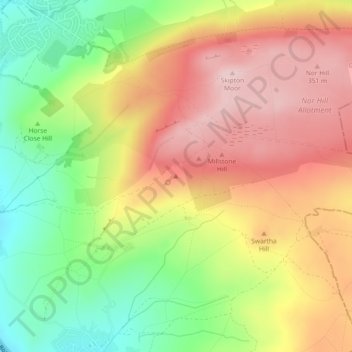
Name: Sheep Hill topographic map, elevation, terrain.
Average elevation: 239 m
Minimum elevation: 101 m
Maximum elevation: 367 m
Other topographic maps
Click on a map to view its topography, its elevation and its terrain.
Settle
United Kingdom > England > Craven > Settle
Settle, Craven, North Yorkshire, Yorkshire and the Humber, England, BD24 9HY, United Kingdom
Average elevation: 269 m
Clapham
United Kingdom > England > Craven > Clapham
Clapham, Craven, North Yorkshire, Yorkshire and the Humber, England, LA2 8EA, United Kingdom
Average elevation: 203 m
nameBarden Fell
United Kingdom > England > Craven > Barden
nameBarden Fell, Barden, Craven, North Yorkshire, Yorkshire and the Humber, England, BD23 6DE, United Kingdom
Average elevation: 337 m
Cowden
United Kingdom > England > Craven
Cowden, Craven, North Yorkshire, Yorkshire and the Humber, England, BD23 4DD, United Kingdom
Average elevation: 284 m
Highgate Hill
United Kingdom > England > Craven
Highgate Hill, Craven, North Yorkshire, Yorkshire and the Humber, England, BD23 3PS, United Kingdom
Average elevation: 141 m