
Unterthumberg topographic map
Interactive map
Click on the map to display elevation.
About this map
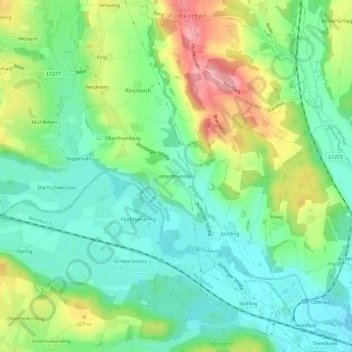
Name: Unterthumberg topographic map, elevation, terrain.
Average elevation: 485 m
Minimum elevation: 440 m
Maximum elevation: 571 m
Other topographic maps
Click on a map to view its topography, its elevation and its terrain.
Rothauptberg
Österreich > Oberösterreich > Bezirk Vöcklabruck > Neukirchen an der Vöckla
Rothauptberg, Neukirchen an der Vöckla, Bezirk Vöcklabruck, Oberösterreich, 4872, Österreich
Average elevation: 652 m