
Thank you for supporting this site ❤️
Make a donation
Make a donation
Wieda topographic map
Click on the map to display elevation.
Thank you for supporting this site ❤️
Make a donation
Make a donation
Wieda
Die Wieda entspringt im niedersächsischen Teil des Harzes im Naturpark Harz. Ihr Ursprung liegt nördlich vom Stöberhai (ca. 720 m ü. NHN) im Westen des Tales Altes Loch: Dort fließen etwas oberhalb einer auf 540,6 m gelegenen Wegstelle zwei kurze Quellbäche auf etwa 545 m Höhe zusammen, die auf den Hochlagen des Berges entspringen und durch das Öhren- und Franzosental verlaufen. Anderen Angaben zufolge liegt Quelle des Flusses „nördlich des Berges Stöberhai“ auf etwa 580 m Höhe.
Thank you for supporting this site ❤️
Make a donation
Make a donation
About this map
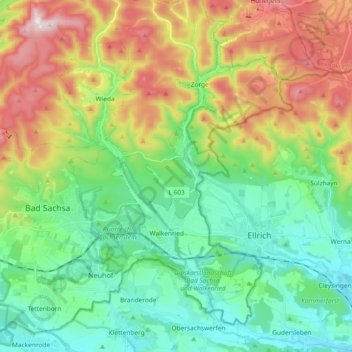
Name: Wieda topographic map, elevation, terrain.
Average elevation: 387 m
Minimum elevation: 218 m
Maximum elevation: 716 m
Thank you for supporting this site ❤️
Make a donation
Make a donation
Other topographic maps
Click on a map to view its topography, its elevation and its terrain.