
Kent topographic map
Interactive map
Click on the map to display elevation.
About this map
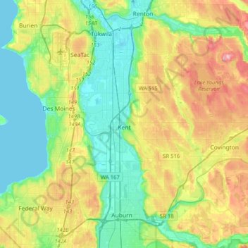
Name: Kent topographic map, elevation, terrain.
Location: Kent, King County, Washington, États-Unis d'Amérique (47.32976 -122.30941 47.44122 -121.99596)
Average elevation: 87 m
Minimum elevation: 0 m
Maximum elevation: 263 m
Other topographic maps
Click on a map to view its topography, its elevation and its terrain.
Maple Valley
États-Unis d'Amérique > Washington > King County
Maple Valley, King County, Washington, 98038, États-Unis d'Amérique
Average elevation: 160 m
Bellevue
États-Unis d'Amérique > Washington > King County
Bellevue, King County, Washington, États-Unis d'Amérique
Average elevation: 66 m