
Thank you for supporting this site ❤️
Make a donation
Make a donation
La Mesilla topographic map
Click on the map to display elevation.
Thank you for supporting this site ❤️
Make a donation
Make a donation
About this map
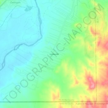
Name: La Mesilla topographic map, elevation, terrain.
Average elevation: 1,727 m
Minimum elevation: 1,690 m
Maximum elevation: 1,809 m
Thank you for supporting this site ❤️
Make a donation
Make a donation
Other topographic maps
Click on a map to view its topography, its elevation and its terrain.
Ohkay Owingeh
United States > New Mexico > Rio Arriba County
Its elevation is 5,663 feet (1,726 m) and it is located at 36°03′12″N 106°04′08″W / 36.05333°N 106.06889°W / 36.05333; -106.06889. One of its boundaries is contiguous with Española, about 25 miles (40 km) north of Santa Fe.
Average elevation: 1,726 m