
Bình Long Town topographic map
Interactive map
Click on the map to display elevation.
About this map
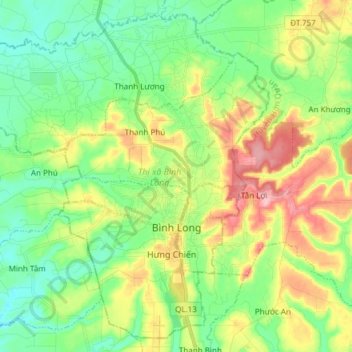
Name: Bình Long Town topographic map, elevation, terrain.
Location: Bình Long Town, Bình Phước Province, Vietnam (11.60464 106.49567 11.74064 106.64673)
Average elevation: 91 m
Minimum elevation: 39 m
Maximum elevation: 186 m
Other topographic maps
Click on a map to view its topography, its elevation and its terrain.
Phường Long Phước
Vietnam > Bình Phước Province > Phước Long Town
Phường Long Phước, Phước Long Town, Bình Phước Province, Vietnam
Average elevation: 209 m
Hưng Long
Vietnam > Bình Phước Province > Chơn Thành Town
Hưng Long, Chơn Thành Town, Bình Phước Province, Vietnam
Average elevation: 62 m
Xã Phước Tín
Vietnam > Bình Phước Province > Phước Long
Xã Phước Tín, Phước Long, Bình Phước Province, Vietnam
Average elevation: 214 m
Nghĩa Bình
Vietnam > Bình Phước Province > Bù Đăng District
Nghĩa Bình, Bù Đăng District, Bình Phước Province, Vietnam
Average elevation: 231 m
Bù Đăng District
Bù Đăng District, Bình Phước Province, Vietnam
Average elevation: 287 m
Phước Long
Vietnam > Bình Phước Province > Phước Long
Phước Long, Bình Phước Province, Vietnam
Average elevation: 202 m