
Thank you for supporting this site ❤️
Make a donation
Make a donation
Koma-Koma topographic map
Click on the map to display elevation.
Thank you for supporting this site ❤️
Make a donation
Make a donation
About this map
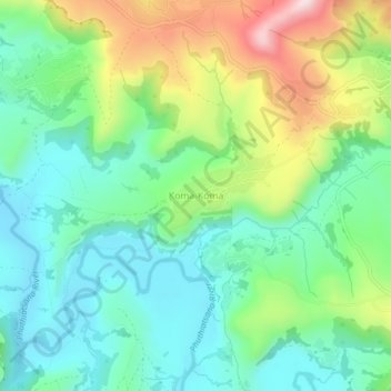
Name: Koma-Koma topographic map, elevation, terrain.
Location: Koma-Koma, Berea District, Lesotho (-29.11817 27.99089 -29.07817 28.03089)
Average elevation: 1,699 m
Minimum elevation: 1,567 m
Maximum elevation: 1,983 m
Thank you for supporting this site ❤️
Make a donation
Make a donation
Other topographic maps
Click on a map to view its topography, its elevation and its terrain.